GIS Data Layers
This website utilizes a specialized
geographic information system (GIS) that was developed for herbicides and the Vietnam War. The GIS allows the user to easily link wartime data on spray missions with data on troop locations, civilian habitations, and other relevant information and to instantly calculate proximity to spray and exposure opportunity scores. We have drawn data from a wide array of paper and electronic sources, which we subjected to extensive quality control. Each kind of data is called a "data layer." Layers with location data are linked to contemporary Google® maps of Vietnam.

|
An updated and corrected version of the Department of Defense electronic file on military herbicide spray missions.
|
|
A searchable list of 11,068 known named locations and dates, with links to associated exposure opportunity scores.
|
|
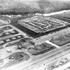
Documents concerning the transfer of land and structures from the U.S. Army Vietnam (USARV) to the Republic of Vietnam Armed Forces (RVNAF).
|
|

|
An electronic index of military units deployed to Vietnam, with links to known locations and associated exposure opportunity scores.
|
|
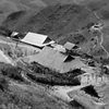
A searchable listing of 2000 distinct villages and 9270 distinct hamlets in the former Republic of Vietnam. Locations are linked to exposure opportunity scores.
|
|
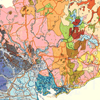
A digitized and searchable version of the 1961 map of soil types by region, developed by the UN-FAO.
|
|